What to See Near Vatnshellir Cave
The best things to see near Vatnshellir cave all sit within 25 minutes of the same car park, on the same stretch of Route 574, and every one of them is free. Basalt pillars five minutes east, a black pebble beach with four fishermen's lifting stones five minutes west, a lighthouse, a cliff full of nesting kittiwakes and a coastal path between two old fishing hamlets. The cave tour lasts 45 minutes, which is why it belongs between two of these rather than instead of them. Pick a departure that suits the day on the guided cave tour.
Quick answer
Within 25 minutes of the cave: Lóndrangar's two basalt pillars, the black pebble beach and lifting stones at Djúpalónssandur, the Malarrif lighthouse and visitor centre, the arches and bird cliffs at Arnarstapi, the coastal path to Hellnar, and Snæfellsjökull itself above all of it. Everything except the cave tour is free.
Key takeaways
- Lóndrangar: two basalt plugs, 75 and 61 metres high, five minutes east
- Djúpalónssandur: four lifting stones from 23 kg to 154 kg, plus the wreck of the Epine
- Malarrif: national park visitor centre, the nearest toilets, lighthouse from 1917
- Arnarstapi to Hellnar: a marked coastal path of about 2.5 km each way
- Snæfellsjökull: 1,446 metres, and Jules Verne's route to the centre of the Earth in 1864
- The park was established on 28 June 2001 and covers about 167 square kilometres
The Short Answer: A Full Day Inside 25 Minutes
Why the cave is a stop, not a destination
Vatnshellir takes 45 minutes underground. The drive from Reykjavík is two hours each way. Those numbers only work if the cave is one item on a list, and fortunately the western tip of Snæfellsnes is generous: within a quarter of an hour of the car park you can be standing on a black beach, under a bird cliff or beside a lighthouse.
Everything on this page is inside Snæfellsjökull National Park, which was established on 28 June 2001 and covers about 167 square kilometres (16,694 hectares) of the peninsula's western end. The park charges nothing to enter and nothing at any of the sites below.
Everything Within 25 Minutes, in Driving Order
The table to plan from
Times are from the cave car park. Allowances assume you actually get out of the car rather than photographing from the window.
| Stop | Direction | Drive time | Allow | Cost |
|---|---|---|---|---|
| Malarrif and the lighthouse | East | 3 min | 20 min | Free |
| Lóndrangar viewpoint | East | 5 min | 20 min | Free |
| Djúpalónssandur and Dritvík | West | 5 min | 45 min | Free |
| Arnarstapi | East | 10 min | 1 hour | Free |
| Hellnar | East | 12 min | 30 min | Free |
| Arnarstapi to Hellnar coastal path | East | 10 min to trailhead | 1.5 hours return | Free |
| Saxhóll crater | North | 20 min | 30 min | Free |
| Hellissandur | North | 25 min | Fuel and food | Free |
How to sequence it
Book a midday cave departure and split the day around it. Djúpalónssandur first, because it takes the longest and rewards an empty beach. Then the cave. Then Lóndrangar and Malarrif on the way east, and finish at Arnarstapi with the coastal path if the light holds.
That order also solves the toilet problem: there are none at the cave, and Malarrif is the nearest at three minutes. Go before, not after.
Map of the Stops
Everything within 25 minutes of the cave car park. Only the cave itself costs anything.
Lóndrangar
Two pillars, five minutes east
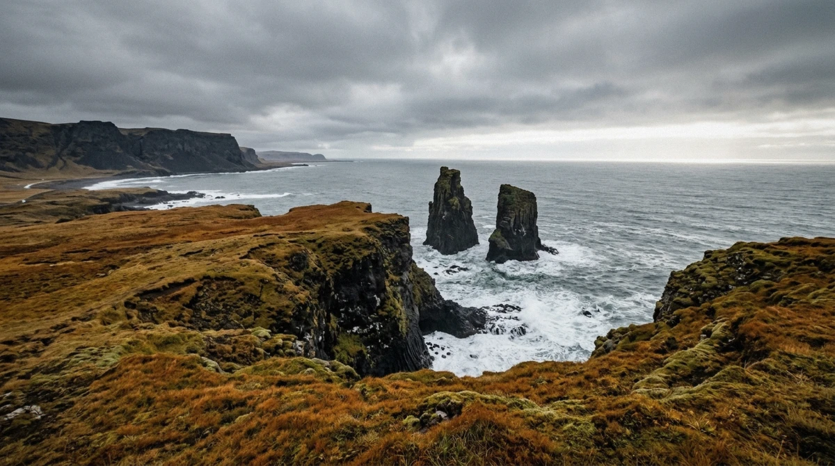
Lóndrangar is a pair of basalt plugs standing 75 and 61 metres out of the coast, the hardened throats of a volcano whose softer flanks the sea has taken away. They sit due east of Malarrif, with a viewing platform signposted straight off Route 574 and a short walk from the car park to the edge.
This is the easiest stop on the road: twenty minutes, no walking to speak of, and the best return on effort of anything on the peninsula. In autumn the moss around it goes rust-coloured and the pillars photograph better than in July.
There is a longer path down towards the base for anyone with time. Do not go looking for a route to the pillars themselves; there is no safe one, and the cliff edges here are undercut.
Djúpalónssandur and the Lifting Stones
The stop with the story
Five minutes west of the cave, a track drops to a beach of black pebbles rounded by the Atlantic. Two things are on it.
The first is four stones. During the sixteenth and seventeenth centuries this beach supported a busy fishing station at Dritvík, and men who wanted a place rowing a boat had to lift a stone onto a plinth at waist height to qualify. They are still there, still named, and people still try. Amlóði, the useless one, is 23 kg. Hálfdrættingur, the weakling, is 54 kg. Hálfsterkur, half-strength, is 100 kg. Fullsterkur, fully strong, is 154 kg, and lifting that one was the qualification.
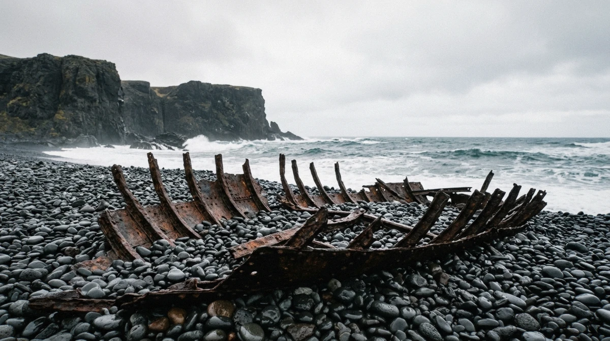
The second is the wreck. Rusted iron ribs lie scattered across the sand: the remains of the British trawler Epine GY7, which ran aground here in 1948. They are a protected historical monument, so nothing may be picked up or taken away, and they have been left where the sea put them.
A warning worth taking seriously
The water here kills people. The beach shelves steeply into open Atlantic with no shelter and no lifeguard, and sneaker waves run much further up the sand than the previous ten waves suggested. Stay well back from the waterline, keep children within arm's reach, and do not turn your back on the sea to take a photograph.
Allow 45 minutes. It is a ten-minute walk down and a slower one back up.
Malarrif and the Lighthouse
Three minutes east, and the practical stop
Malarrif does two jobs. It has the national park visitor centre, which is where the rangers sit and where the nearest toilets to the cave are, three minutes along the road. And it has a lighthouse: the first went up in 1917 and the current one replaced it in 1946, a plain white tower on a flat black shore.
The walk from the lighthouse east along the shore towards Lóndrangar takes about twenty minutes each way and is the quietest bit of coast on this side of the peninsula. Almost nobody does it because the pillars have their own car park further along.
If you only have time for one practical stop before the cave, make it this one.
Arnarstapi and Hellnar
The arch and the birds
Arnarstapi is ten minutes east of the cave and the closest thing to a village on this stretch: fuel, a place to eat, and a small harbour under a basalt shore. Gatklettur, the stone arch, sits a couple of minutes' walk from the car park, and the low cliffs beside it are loud with nesting kittiwakes through the summer. There is also a large stone troll, Bárður Snæfellsás, which children reliably prefer to any of the geology.
Hellnar is twelve minutes east, smaller and older, with a sea cave at the shore and a café that has been there long enough to be a landmark itself.
The coastal path between them
A marked path runs along the low cliffs between the two hamlets, about 2.5 km each way, or 5 km if you walk it out and back rather than arranging a car at each end. It is the best short walk on the peninsula: arches, columns, sea caves and birds the whole way, with no climbing involved.
Allow an hour and a half for the return trip at a proper look-at-things pace. It is exposed, so the wind decides how pleasant it is; the monthly wind figures for this coast are worth a glance before you commit to it.
Snæfellsjökull Itself
The mountain above everything
Snæfellsjökull is a 1,446-metre glacier-capped stratovolcano at the western end of the peninsula, visible from Reykjavík across the bay on a clear day, 120 km away. It is the reason the national park exists and the reason the cave below it is there at all: the lava that drained out of Vatnshellir came from the Purkhólar crater row on its lower slopes.
It is also the mountain Jules Verne picked in 1864 as the entrance to the centre of the Earth, which the cave operator has been leaning on ever since. Verne never visited Iceland.
Going up requires a guided snowcat or ski tour, is weather-dependent, and takes most of a day. From the road you get it as a backdrop, which for most visitors is the right amount of it.
Sönghellir, if you have twenty minutes
Sönghellir, the singing cave, sits on the slope above the park off the F570 mountain track. It is a small chamber known for its echo, carved with visitors' names going back centuries. There is no tour, no staircase and no guide; you walk in with a torch.
It is a curiosity rather than a destination, and worth it mainly for the contrast with what a guided lava tube is actually like.
Park Rules That Catch People Out
Three that are enforced
This is a national park rather than open countryside, and rangers do work this stretch of road.
- Stay on marked paths. The woolly fringe moss on the lava takes decades to recover from a single footprint, and walking on it is prohibited rather than frowned at
- Do not take anything. That includes pebbles from Djúpalónssandur and any fragment of the Epine, which is a protected monument
- Drones need permission inside the park, and the bird cliffs are closed to them in nesting season
- Camping is only at designated sites, not in the lava field car parks
- No off-road driving of any kind, which in Iceland is a criminal offence rather than a fine
Why the moss rule is not fussiness
Woolly fringe moss grows on bare lava at a rate measured in millimetres a year. A footprint through it leaves a visible scar for decades, and a path worn by a hundred people leaves one for a century. The gravel track between the cave car park and the hatch exists precisely so that nobody needs to walk on the moss, and it is ninety seconds long.
A One-Day Route From Reykjavík
The version that works
Two hours out, two hours back, and 136 km each way. Everything in between is choosing what to leave out.
| Time | Where | Why |
|---|---|---|
| 08:00 | Leave Reykjavík | Route 1, the tunnel, then Route 54 west |
| 10:15 | Arnarstapi | Coffee, the arch, the bird cliff |
| 11:15 | Djúpalónssandur | The lifting stones and the wreck, before the coaches |
| 12:15 | Malarrif | Visitor centre and toilets, three minutes from the cave |
| 12:45 | Vatnshellir Cave | Book this departure; arrive 10 minutes early |
| 13:45 | Lóndrangar | Twenty minutes at the viewpoint |
| 14:30 | Hellnar or the coastal path | Whatever the light and the wind allow |
| 16:30 | Start back | Reykjavík by about 18:30 |
If you only have half a day
Cave, Lóndrangar, Djúpalónssandur, in that order, and skip Arnarstapi. That is three hours on the peninsula and it still justifies the drive. The full route from Reykjavík has the road legs and the winter caveats.
What to Do With the Time You Have
If you have a full day from Reykjavík
follow the schedule above. Nine or ten hours door to door and you will have seen the western tip properly.
If you have three hours on the peninsula
cave, Lóndrangar, Djúpalónssandur. Skip the coastal path.
If you are travelling with young children
Djúpalónssandur and the lifting stones beat every viewpoint here. If one child is under 5, the cave is out for whoever stays with them.
If you are here in December
take the first cave departure and add Lóndrangar. Four hours of daylight does not stretch further than that.
If the wind is up
the cave and Lóndrangar's platform still work. The beach and the coastal path do not.
Near Vatnshellir Cave: Common Questions
What to see at Snaefellsnes Peninsula?
On this western tip, inside 25 minutes of the cave: the Lóndrangar basalt pillars, the black beach and lifting stones at Djúpalónssandur, the Malarrif lighthouse and visitor centre, the arch and bird cliffs at Arnarstapi, the coastal path to Hellnar, and Snæfellsjökull above all of it. Kirkjufell, the mountain most people picture, is on the north coast about an hour and a half away and belongs to a different day.
How long is the Vatnshellir cave tour?
45 minutes underground, about an hour at the site with the briefing. That is short enough to fit between two of the free stops above rather than replacing them.
Is Vatnshellir cave worth it as part of a Snæfellsnes day?
Yes. It is the only thing on this stretch of Route 574 you cannot see from the road, and at 45 minutes it costs you very little of the day. As a destination on its own, driving four hours for it, no.
Are the nearby stops free?
All of them. The national park charges no entry fee and none of the sites has a ticket. The cave tour is the only thing on this road you pay for.
Can I swim at Djúpalónssandur?
No. It shelves steeply into open Atlantic with sneaker waves that run far up the sand, and people have died there. Stay well back from the water and keep children close.
Where are the nearest toilets?
The Malarrif visitor centre, three minutes east of the cave car park. There are none at the cave itself, so stop on the way in.
How far is Kirkjufell?
About an hour and a half by road on the north side of the peninsula. It is a full-loop day rather than an add-on to the cave, and trying to do both plus the coast in one winter day does not work.
Can I walk on the moss for a photograph?
No, and it is prohibited rather than discouraged. Woolly fringe moss grows millimetres a year and a footprint stays visible for decades. Stay on the marked paths, including the ninety-second gravel track to the cave hatch.
The cave earns its 45 minutes, but the reason to drive out here is the road it sits on. Two pillars, a black beach with four stones on it that decided men's livelihoods, a lighthouse and a cliff walk, all of it free and all of it inside a quarter of an hour. Book a midday departure and build the day either side of it.